


Heavy rain over the next week and the impacts from a potential tropical storm could bring major flooding to the area this week through the weekend, according to the National Weather Service.
Two rain events – one beginning tonight and another later this week – will bring flooding to roads, lawns and crops that haven’t seen any significant amount of rainfall since Long Island went into a drought in May.
The first heavy rainfall is expected to start late tonight and last through tomorrow, dumping between two and four inches of rain before it passes. That’s the equivalent of nearly a month’s worth of rainfall, according to Tim Morrin, an observation program leader and meteorologist at the National Weather Service.
“This will be the kind of rain that we haven’t really seen in a very long time,” Morrin said.
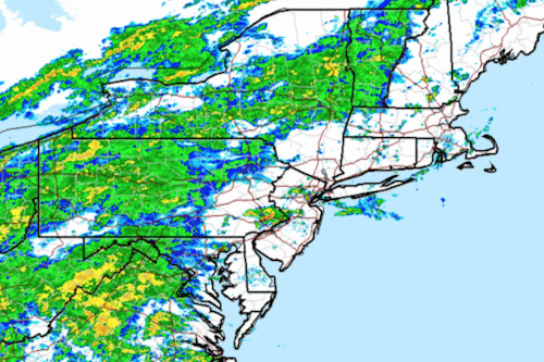
The rain may be so heavy, however, that it could actually become too much for the ground, which has grown dry and hard throughout the summer’s drought.
“The rain is expected to come down very hard and fast,” Morrin said. “That means the rain might not get a chance to soak in at all, but rather run off.”
The possibility of roadway and intersection flooding will be a concern, he said.
But the real flooding may happen this weekend, when Tropical Storm Joaquin is expected to move up the coast.
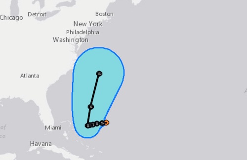
Although Joaquin is too far out for meteorologists to make any certain forecast, the rain this storm could bring, even if it never makes landfall, has the potential to create major flooding, especially in the Peconic River, Morrin said.
With the current forecast, Joaquin would create a period of “tidal piling” – water being pushed from the Atlantic Ocean into the Peconic Bay by the northeast winds from the storm. The water would have no where to go but the Peconic River, where it would likely rise over the banks and cause significant flooding.
“That entire mass of water would be funneled up into the river,” Morrin said. “The riverbanks only have a certain capacity to hold a certain mass of water.”
The Peconic River is historically prone to flooding, and often submerges the riverfront parking lot off of Main Street in heavy rain events. During Hurricane Sandy in 2012, the river rose several feet downtown, completely submerging cars and spilling into the street.
A more definitive forecast will take shape later in the week as the storm makes its way up the coast and its path and speed become more certain, Morrin said.
But even with all the rain, the possibility of Long Island emerging from its drought anytime soon is unlikely.
“It takes a long time to get in a drought, and it takes a relatively long time to get out of a drought,” Morrin said. “One or two rain events cannot erase the deficit rain we’ve had for a period of months.”
The survival of local journalism depends on your support.
We are a small family-owned operation. You rely on us to stay informed, and we depend on you to make our work possible. Just a few dollars can help us continue to bring this important service to our community.
Support RiverheadLOCAL today.