


Main Road Historic Resource Survey
Riverhead, New York
Sponsored by
Riverhead Landmarks Preservation Commission
200 Howell Avenue,
Riverhead, NY 11947
Prepared by
Richard Wines, Ph.D., Chair
Riverhead Landmarks Preservation Commission
Photography by Cliff Baldwin
February 20, 2013
Introduction
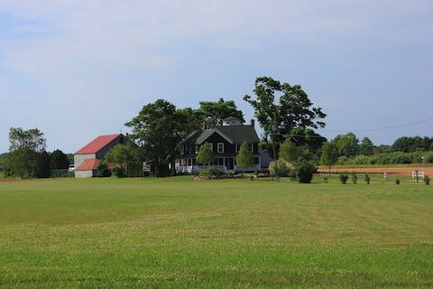
The Main Road Historic Resource Survey covers nearly five miles of semi-rural Route 25 as it winds through the hamlets of Aquebogue, Jamesport and part of Laurel in the Town of Riverhead. The area encompasses a rich agricultural landscape and one of the longest settled parts of the town of Riverhead. Historic buildings and farms dating from the 18th, 19th and 20th centuries line the roadway. The pattern of relatively dense linear development along a single principal roadway may be relatively unique among agricultural regions of the state.
The Riverhead Landmarks Preservation Commission has identified this corridor as a potential National Register Historic District. This survey is intended as a first step in identifying and assessing the significance of the Main Road historic resources. We have identified more than 230 structures and other historic resources in the survey area that are more than 50 years old and that we believe could qualify as contributing resources in a future National Register Historic District. These potential contributing resources constitute approximately 82% of the total number of structures in the survey area.
Physical Landscape
Main Road traverses a relatively flat rural landscape once typical of much of Long Island, but now increasingly rare. The entire length of the survey area was and still is an important agricultural area. For reasons described below, the farm structures are relatively densely clustered along this single road, rather than scattered throughout the landscape or clustered in village centers with a church and green as is the case in many other long settled parts of the Northeast. This unusual pattern can be clearly seen on the 1858 Chace map of the area. Of the 133 homes that show up on that map in the communities of Aquebogue, Jamesport and Laurel, 106 or 80% are on Main Road itself, with only 27 scattered along various side roads. Similarly, on the 1873 Beers map, of the 149 homes in the three communities, 122 or 82% are along Main Road itself.
For most of its distance, farmland stretches north and south of the road, although it is often obscured by the band of buildings immediately along the highway. There are some modern housing developments visible in the distance, but these are seldom immediately on Main Road. There are two hamlet centers with small groupings of commercial buildings, but these did not develop until the late 19th and early 20th centuries. There are also scattered examples of roadside architecture emblematic of the rise of the automobile culture in the 1920s, 30s and 40s.
Historical Significance
Main Road History
Main Road is itself an historic artifact. And, in some ways the name says it all. This is indeed the main road on the North Fork of Long Island. Over the centuries, Main Road has had several different names. Today the name is generally used for that section of New York Route 25 running from the intersection with County Route 58 east to Orient Point at the tip of the North Fork. From that intersection west to downtown Riverhead, Route 25 is called “East Main Street.” From there, Route 25 continues all the way west to the Queensboro Bridge in New York City, with many different local names along the way such as West Main Street, Old Country Road and eventually Queens Boulevard.
This route of Main Road was almost certainly a path well trod by Native Americans in the millennia before the first English settlers arrived in the area During the colonial era Main Road was generally referred to as the “King’s Highway.” At that time, it was mainly the route from Southold and other settlements further east on the North Fork to Riverhead, where it was possible to cross the Peconic River and travel by a land route to South Fork settlements. Very little of the traffic would have continued on westward past Riverhead through the center of Long Island, which was mostly empty at that time, or to New York City.
After the Revolution and throughout the 19th century, Main Road was generally know as “South Road,” while the other east-west artery in the town of Riverhead was called “North Road” (now Sound Avenue). By the early 20th century, the term “Main Road” had become more common. A 1904 deed, for instance, refers to it as the “Main Road from Riverhead to Greenport.”
The roadway itself follows the kind of winding route that characterizes many early roads as they avoided minor impediments in the landscape. In the case of Main Road, the course was mostly determined by the need to skirt the northern limits of a series of creeks that probed inland from the shores of Peconic Bay to the south. Most of these creeks came further north in the 17th century than they do today.
Coming from Mattituck in the east where Main Road crossed the narrow isthmus that the Native Americans called their “Canoe Place” between Reeve’s Creek on the south and Mattituck Inlet on the north, it skirted the northern reaches of Brush’s Creek in Laurel, and then proceeded more or less straight past the end of East Creek near Herrick’s Lane and on to what is now Jamesport hamlet. There it passed between the northern edge of extensive wetlands extending from Peconic Bay on the south and a series of ponds on the north. From there the road curved more to the northwest, proceeded past Tuthill’s Lane where it took a sharp turn to the southwest around another system of wetlands extending from Peconic Bay. Further west, Main Road rounded the north end of Meeting House Creek near Church Lane and meandered along to the headwaters of Terry’s Creek near the intersection with Doctor’s Path and Route 58. From that point, the modern Route 25, called East Main Street in this section, turns sharply southwest towards downtown Riverhead and the crossing to the South Fork.
Main Road has generally followed its current somewhat meandering route since colonial days, except in the area of Aquebogue. There approximately between Tuthill’s Path and Doctor’s Path it originally looped further to the north. This route may have allowed it to skirt around the north side of the springs and ponds once called “long swamp” that then extended northwards from the head of Meeting House Creek. It may also have allowed access to some houses in an area then called “Frog Town” along a series of small ponds about half a mile north of present Main Road .
Community Names
The names of the communities along Main Road have been in flux for most of the past three centuries. Initially, the whole area was know as “Aquebogue,” which in the 17th century was often spelled “Occabauk” or one of 23 other spellings found in the Southold Town Records. The 1731 Meeting House in Jamesport was first referred to as “ye western most meeting house in Southold” and then simply the “Aquebogue Meeting House.” However, after the dissenters split away in the 1750s to form what is now Old Steeple Church a couple of miles to the west, that area became know as “Upper Aquebogue” while the area around the original meeting house became known as “Lower Aquebogue” or “Old Aquebogue.”
The names changed again in the mid-19th century. The impetus was James Tuthill’s (see 1214 & 1246 Main Road) founding of a small port in the 1830s at the tip of Miamogue Point on Peconic Bay, about a mile south of “Lower Aquebogue,” which he named “James Port” after himself.
When the Long Island Railroad was constructed in 1844, a station was located halfway between Lower Aquebogue and the new port. The station used the “Jamesport” name. When a post office followed the railroad station, it also used the “Jamesport” name and soon both the old and the new areas became know as “Jamesport.” At that time “Upper Aquebogue” simply became “Aquebogue.”
Similarly, the hamlet at the eastern end of the survey area, extending on into Southold Town, was know as “Middle District” and then as “Franklinville” during most of the 19th century, presumably in honor of Benjamin Franklin’s historic carriage trip down Main Road laying out mile markers in 1755. But, at the turn of the 20th century, when that hamlet wanted its own post office, the name “Franklinville” was already taken by a town upstate, so they changed the name to “Laurel” after Laurel Lake, the most prominent water feature in the hamlet.
17th Century Land Allotments and Eleven O’clock Lines
The entire North Fork as far west as Wading River was part of the Town of Southold from the earliest English settlements in the 1640s until Riverhead was finally set off as a separate town in 1792. Originally, the entire western part of Southold, then called “Aquebogue” was considered common land belonging to all of the citizens of Southold, who were mostly part of the large-scale 1630s Puritan exodus from England.
On the Petty-Zaleski farm at 1748 Main Road in Jamesport, both the 19th century hay barn and the adjacent mid-20th century potato barn are oriented parallel to the farm’s eleven-o’clock line boundaries rather than perpendicular to Main Road.
At a town meeting on November 20, 1661, after they had managed to get Native American signatures (actually marks) on several pieces of paper that provided the veneer of legality, the freeholders of Southold decided to divide the area called “Occabauk” (“Aquebogue”) into lots running from “sea to sea” – i.e., from Long Island Sound on the north to Great Peconic Bay on the south. The “First Aquebogue Division” included 39 allotments and covered the area starting at the “Canoe Place” at the head of Mattituck Inlet and ran west almost to Union Avenue and included forty lots. A few years later, in 1676, the “Second Aquebogue Division” created 44 more lots extending as far west as Fresh Pond Avenue. By 1711, all of the rest of the town was divided into allotments except for the southwest corner that was part of St. George’s Manor.
Each lot was approximately 3.5 miles long, but only forty rods or 660 feet wide, and contained about 250 acres. The boundaries dividing the allotments were known as “eleven o’clock lines,” supposedly because of the direction of the sun’s shadows at that time of the day. More likely this was a surveyor’s term for a line that was 30 degrees west of magnetic north – or at the eleven o’clock position on the compass dial. The goal was to create parcels with boundaries roughly perpendicular with the shores of Long Island Sound and Great Peconic Bay.
The impact of the 1661 and 1676 Aquebogue Divisions can still be seen in several ways on the physical landscape. First of all, most of the property boundaries, and the side roads that paralleled them, still follow the old eleven o’clock lines. Second, because the original allotments were so long and narrow, over the generations they tended to be subdivided into narrow strips, sometimes referred to locally as “bowling alley farms,” with a relatively small frontage on Main Road where the homes and farmsteads could be located. Because these farms were often only a few hundred feet wide, but sometimes a mile or more long, this resulted in a closely spaced string of farm houses along Main Road — something very different from most other agricultural landscapes in New England, upstate New York or other parts of the country.
And finally, many of the buildings along Main Road were either intentionally or inadvertently aligned with their fronts perpendicular to these eleven o’clock lines. The oldest building the survey, the 1731 Jamesport Meeting House is set on one of these lines, as is Old Steeple Church in Aquebogue. The gravestones in both the 1732 Jamesport Cemetery and the slightly newer Aquebogue Cemetery are all aligned in rows that follow these lines.
Sometimes the lines just happened to be perpendicular to Main Road, resulting in farmsteads that were laid out on a rectangular grid that fit both the eleven-o’clock lines and the roadway. However, in areas where the curvature of the roadway created different angles, farmsteads were often laid out parallel to the eleven clock lines rather than perpendicular to the road. The best example of this practice is the Petty-Zaleski farm at 1748 Main Road in Jamesport. The side walls of both the 19th century hay barn and the mid-20th century potato barn next to it parallel the farm boundaries on those eleven-clock lines and are not perpendicular to Main Road, which runs at a sharp angle to the lines in that area.
18th Century Puritan Pioneers
The Main Road corridor was the first area of what is now Riverhead Town to be thickly settled. Pioneers began drifting west from the original Puritan settlement in Southold in the last decade of the 17th century. These were the men who gathered in 1731 to build the Jamesport Meeting House, still standing at 1590 Main Road and the oldest structure in the survey area. When these pioneers got together to build that meeting house, there were 21 homesteads in what later became the Town of Riverhead, according to a map in Virginia Wines, Pioneers of Riverhead Town, p. 75. Twelve of these homes, more than half of the total, were located along the five miles of Main Road in our survey area, even though the area is only about 10% of the future town’s land area.
The 1865 Youngs-Wells-Anderson House at 1125 Main Road in Jamesport is located about 1,000 feet south of the highway, on the site of the c.1700 Christopher Youngs homestead — typical of the location of first period homes scattered around the landscape instead of clustered along Main Road.
None of these first homes survive, although many of the pioneers are buried in the two 18th century cemeteries along Main Road. However, their family names — Wells, Downs, Young, Terry, Warner — show up often in our survey because many of the existing homes were built by descendants of these early settlers on land inherited from those settlers. The circa 1800 D.W. Hallock House at 290 Main Road in Aquebogue is a good example.
Hallock’s wife was a direct descendant of the Riverhead pioneer who settled in this area, Nathaniel Wells (1705-1781), one of four brothers who moved here from Cutchogue about 1726. Like his brothers, Nathaniel was amongst the men who gathered in 1731 to build the Jamesport Meeting House
Similarly, the 1865 Youngs-Wells-Anderson House at 1125 Main Road in Jamesport is built on the home site of pioneer settler Christopher Youngs (1677-1727) . Like many of the first generation, Youngs did not build his house directly on Main Road, but rather at a location determined by soil and water — in this case about 1,000 feet south of Main Road. George Frank Wells (1832-1903) inherited the property through his wife, a Youngs descendant. Although Wells built most of the house in 1865, he incorporated parts of a much older house, possibly Youngs’s. The circa 1770 Squire Halsey Young House next door at 1117 Main Road was built by another direct descendant of Christopher Youngs.
From the beginning, the Main Road corridor played an outsize role in the future town of Riverhead’s history. It was the location of the town’s first two meeting houses — 1731 in Jamesport (still standing) and the circa 1758 first structure of Old Steeple Church in Aquebogue. Main Road also has the two oldest cemeteries in the town, Jamesport, opened in 1732 and Aquebogue with its first burial in 1755. When Riverhead separated from Southold in 1792, not surprisingly it was men along Main Road who became its leaders. Of the fifteen men who served as supervisors during its first 50 years as a separate town, eleven lived on or near Main Road and thirteen are buried in its cemeteries. Of the other two, one was married to a Jamesport girl.
Only the well curb survives from the 1756 home and tavern of David Tuthill, the birthplace of James Tuthill after whom Jamesport is named. It now stands in front of the 1938 house built by Polish immigrant farmer Martin Gatz at 1246 Main Road after the old house burned.
Although many of the earliest houses were not located directly on Main Road, which was still a rather insignificant path, by the second half of the 18th century, most new homes were being built on the highway, a sign of its increasing importance. Houses not near the highway were sometimes moved up to the highway. These homes were all the generic small story-and-a-half side gable design typical of the North Fork in the period (see below).
Eight homes from the second half of the 18th century survive along Main Road, generally as barely recognizable portions of buildings much modified in the 19th century. For instance, the original part of the oldest house in the survey area, the circa 1758 Griffing-Wells House at 396 Main Road in Aquebogue, is just the bottom half of the current house. Similarly, the original part of the circa 1772 Conklin-Aldrich House at 1612 Main Road (today Junda’s Bakery) is just the first floor of the right side of the current house. The mid-18th century structure buried inside the Jamesport Parsonage at 1587 Main Road is totally hidden, as is the mid-18th century part of the Washington Wells house at 949 Main Road in Aquebogue.
A few of these original half-houses appear as side wings of later house — such as the circa 1770 story-and-a-half right wing of the Wells-Hutchinson House at 939 Main Road. The first floor of the right wing of the Judge John Woodhull house at 1662 Main Road in Jamesport is probably the original 1780 house. And at the Squire Halsey Young house in Aquebogue, the original 1780 house appears as the back wing of the current structure.
The only surviving 18th century standalone story-and-a-half structure is the Old Corwin House at 612 B Main Road. Ironically it was once incorporated as a side wing of the 1831 gambrel roof house next door, but later separated to serve again as a single home.
One other curious artifact survives along Main Road from the 18th century, the Tuthill well curb in front of the 1938 Gatz house at 1246 Main Road in Jamesport. This was the site of the home David Tuthill (1775-1861) built in 1756 and was the birthplace of James Tuthill after whom Jamesport is named. David Tuthill’s house included both a tavern and a store. It was also a stage coach stop on the route from Orient to New York. The house burned down in 1937, but the well that stood in front of the tavern survived. An old photo shows both the old Tuthill house and the well with its wooden sweep still intact.
Slavery
At least four buildings along Main Road bear witness to slavery, a practice that was well established in the area before the Revolution and continued for several decades afterwards. Analysis of the 1790 federal census data indicates that 45 to 55 slaves lived in the area that became Riverhead two years later — approximately 4.5% of the total population. Between 1776 and the end of slavery in New York State in 1827, at least 55 Riverhead families owned slaves, or about a quarter of the households in the town. Given that Main Road was the most densely populated and most prosperous parts of the town, is likely that a disproportionate portion of the town’s slave population lived along its route.
The list of slaveholders includes many of the town’s leading citizens. Some of them were literally the town’s founding fathers such as David Conklin, who lived in the gambrel-roofed house at 1086 Main Road in Jamesport. He was the clerk at the town’s organizational meeting in 1792 and served as Riverhead’s second supervisor – in addition to being the town’s first physician. In 1790 he held two slaves who lived side by side with two free blacks in his household. In 1800 he owned four slaves.
His neighbor Judge John Woodhull, whose house still stands a little to the east of Conklin’s at 1662 Main Road, was also a slaveholder — not surprising in that he may have been the town’s wealthiest person at the time. In addition to being a county judge, he served several times as town supervisor in the early 19th century and was Riverhead’s leading agricultural reformer.
Even clergy, presumably the moral leaders of the town, were slaveholders. Rev. Benjamin Goldsmith, a 1760 Yale graduate who served from 1764 to 1810 as pastor of the Presbyterian union parish of Mattituck and Jamesport, (see Jamesport Meeting House, 1590 Main Road) owned one slave in the 1790 tally and two in 1800. Although Goldsmith was described as a man of “sound mind, solid acquirements … and of unfeigned piety,” neither his religious convictions nor his college education led him to reject human bondage. He still held a slave in 1810 at the time of his death.
 The Rev. Daniel Youngs, the minister from 1782 to 1814 of Old Steeple Church in Aquebogue, held two slaves according to the 1790 census. He lived in the original 1770 wing of the Squire Halsey Young House at 1117 Main Road.
Similarly, the 1790 census reveals that Daniel Youngs, the minister from 1782 to 1814 of the fiercely independent “Strict Congregational Church” of Upper Aquebogue (now Old Steeple Community Church), held two slaves. His son, Daniel Youngs, Jr., also owned a slave in 1790. Although both apparently had no compunctions about their slave ownership before 1800, they changed their opinions of slavery as moral leaders of the state began to question the institution. Neither owned slaves in the 1800 or 1810 census years.
Both of the historic cemeteries in the Main Road survey area likely contain numerous slave graves. However, most of these are neither recorded nor marked The only recorded graves of ex-slaves are for ʺBristerʺ who died in 1839 at age 80 and his wife Zipporah who died in 1806 at age 50 and their six children. The cemetery’s records describe them as ʺColored Slaves” of Rev. Daniel Youngs (see above). Brister was probably freed before his death and his wife certainly was, as the 1800 census shows that Youngs no longer owned any slaves. However, from 1800 through 1830, federal census returns do show a free black household headed by a man named either “Busterʺ or ʺBrewsterʺ Youngs. Very likely “Buster” was either the same person as “Brister” or his son.
Revolutionary War
Like the rest of Long Island, the Main Road area was occupied by the British in 1776 after George Washington’s defeat at the Battle of Long Island. The occupation lasted for the duration of the Revolutionary War. A few men from the area are know to have served in the war. Still others fled with their families to live out the war as refugees in Connecticut. The vast majority, however, signed an oath of loyalty to the British Crown so that they could stay in their homes.
 Both John Griffing and Joseph Wells, the first and second owners of the 1758 Griffing-Wells House in Aquebogue, served in the Revolution and were forced to flee to Connecticut as refugees after the British occupied all of Long Island in 1776.
 Like other local patriots, Dr. David Conklin, who built the first part of this house at 1612 Main Road in Jamesport, was forced to flee to Connecticut as a refugee when the British occupied Long Island in 1776, just four years after he built the first part of this house. Conklin served in the Hospital Service during the Revolution.
According to Georgette Case, Riverhead Town Historian, there are 49 “patriots” buried in the Aquebogue Cemetery and another 27 in the Jamesport Cemetery. These are men who indicated their patriotism by signing the Brookhaven Association before the Revolution. Many of them also mustered as Minutemen at the time. However, after the British occupied Long Island, most of these men also signed the oath of loyalty to the crown.
No battles were fought in the area, but there was probably a British encampment in Aquebogue. Indeed, those soldiers may have been responsible for altering the route of Main Road from its original course north of Old Steeple Church to its present course south of the church. There is a story about a British soldier being denied service at the blacksmith shop later run by the Magee family (see 640 Main Road). An amateur archeologist has found buttons and other identifiable artifacts from British uniforms in that area.
19th Century: Increasing Agricultural Prosperity
The area was never wealthy in the 18th century and recovered slowly from the economic devastation of the Revolution and British occupation, as well as the impact of Hessian Fly on wheat crops and the general exhaustion of the sandy soils. However, agriculture began to become increasingly prosperous in the area by the 1830s and 40s, as is reflected by the appearance of two-story homes of increasing size along Main Road in that period (see the Israel Fanning house at 2092 and Judge John Woodhull house at 1662 as examples).
This new prosperity was partly the result of the growth of urban markets at the other end of Long Island in Brooklyn and New York City. It was also a function of the increased availability of transportation, first with the new port at Jamesport in the 1830s and especially after 1844 when the Long Island Railroad extended its main line to Greenport. The railroad runs about a half mile to the south, parallel to Main Road. Stations were built in Laurel, Jamesport and Aquebogue. The latter two became two of the most important on the whole Long Island system for freight traffic, most of which was agricultural produce.
Another factor that led to this agricultural revitalization was the increased use of fertilizer — first fish that Main Road farmers caught in Peconic Bay, next guano from Peru brought into the new port at Jamesport and later “fish guano” such as was manufactured by the Hawkins brothers’ company (see Edward Hawkins at 1945 Main Road in Laurel and Jedediah Hawkins at 400 South Jamesport Avenue, Jamesport).
This growing prosperity is reflected in the size and style of the farmhouses built or enlarged in the second half of the 19th century. As the century progressed, second stories were added to the old houses. Even more often new wings were built that were much larger than the original houses. Many examples survive on Main Road. It was in this period that the 18th century original wings of the Judge Woodhull and Wells Hutchinson houses mentioned above received their newer and much larger additions. It was also in this period that many of the sprawling farmhouses, such as the Avery Young House at 952 Main Road in Aquebogue or the Skidmore-Penny-Boucher house at 1982 Main Road in Laurel took on the present size.
Carpenters’ Houses
At the same time, occupational diversity of the residents increased considerably. From the earliest settlement and well into the 20th century, most of the inhabitants along Main Road made their living directly from agriculture. During the 19th century, however, a substantial sprinkling of professionals, tradesmen and merchants developed along Main Road. This contrasts sharply with the town’s other main east-west corridor, Sound Avenue, where as late as the 1920s every taxpayer was a farm owner.
For some reason, carpentry became a favored profession. Of the 93 houses surviving along Main Road from before 1920, at least 15 or 16.1% were built by carpenters for their own use. When building for themselves, these carpenters tended to build houses that were more up to date and architecturally sophisticated than the homes put up by their farmer neighbors.
For example, both the house Alva Corwin built in 1827 for himself at 534 Main Road or the one Rogers Aldrich rebuilt in the 1840s at 1612 Main Road are examples of the more-difficult-to-frame gambrel roof design. One of the most spectacular homes along Main Road is undoubtedly the one that John Elliot Aldrich built in 1873 for himself at 621 with its many gables, false windows to provide symmetry and rich combination of Italianate and Gothic design elements. Aldrich’s handiwork is also on display in the elaborate shingled interior of Old Steeple Church in Aquebogue or the picture-perfect Carpenter Gothic house he built in the 1870s for John Henry Wells at 497 Main Road.
 The 1873 John Elliot Aldrich House at 621 Main Road in Aquebogue is one of the most spectacular homes built by carpenters for themselves.
Because carpenters, like farmers, seemed to run in families we also have a house built by Alva Corwin’s carpenter son John at 470 Main Road and by his carpenter grandson Harry at 621 Main Road. Both are more sophisticated designs that found on surrounding farm houses. Alva’s other carpenter son, Oliver, lived at 612 Main Road across from Harry in another gambrel roof house also built by his father. Similarly, Fred Hallock built himself a house at 1833 Main Road around 1900. Then, his three sons, all carpenters, built homes immediately to the west.
Farmer’s-son carpenters continued to build unusually nice homes for themselves well into the 20th century, such as Joe Berg’s spacious circa 1925 house at 1686 Main Road in Jamesport or Frank Trojanowski’s handsome bungalow at 325 Washington Avenue. It is unclear why descendants of so many Main Road farm families took up carpentry as a profession. No other trade is nearly as well represented here and there were no carpenters along the similar stretch of Sound Avenue to the north.
Sea Captains’ Homes
In the middle decades of the 19th century, a number of sea captains made their homes along the eastern portion of Main Road. The most prominent were the brothers Edward Hawkins, at 1945 Main Road and Jedediah Hawkins at 400 South Jamesport Avenue. Both built large Italianate mansions. Also in the Italianate style was the house that Capt. Austin Penny built for himself around 1872 at 2014 Main Road in Laurel. His son, Capt. George Penny significantly enlarged and modernized the already spacious 1850 structure at 1982 Main Road that he inherited from his wife’s Uncle, George Skidmore. A little further east, Capt. Robert Wilbur, master of the whaling ship Washington out of Jamesport, acquired an old Fanning family house and added a Greek Revival addition to it in 1836. That house has now been moved for preservation to 73 Winds Way in Jamesport
Early 20th Century: Polish Immigrants Transform the Area
Starting just before the beginning of the 20th century, Polish immigrants started flooding into the area. They were pushed out of their homeland by economic and political pressures in Czarist Russia. They generally first found work on local farms as laborers. But they were hardworking and came from a part of Poland where the agricultural economy was very similar to eastern Long Island, so it is not surprising that these families soon began buying up local farms. By 1930, of the 86 households along Main Road, 23% were headed by either first or second generation Polish immigrants.
 Polish immigrants Joseph and Josephine Wowack demolished an early-18th century home and built this spacious four-square in 1924 to accommodate their large family with nine children.
There are numerous examples of first, second or third generation Polish farm families, such as the Zbybs at 1622 Main Road, the Wowacks at 1234 and 1322, the Sieminskis at 1639, Gergelas at 1158 and Zaweskis at 1722, 1748 and 1945 Main Road. Even some of the Anglo and Scandinavian sounding names like Anderson (see 1125 Main Road), Kane (1284 Main Road), Case (1660 Main Road) and McKay (641 Main Road) were actually Polish immigrant families who changed their names. Thus Andruskiewicz became “Anderson” or “Andrews,” “Czerepinski” became “Case” and Sinchuck became “Kane.”
Polish immigrants also found their way into various trades and professions such as carpenter Frank Trojanowski at 325 Washington Avenue or funeral director Peter Danowski at 299 Shade Tree Lane. Auto mechanics was a particularly big draw. Leonard Fisher, whose garage was at 1403 Main Road, Charles Trinowski whose Texaco station was at 1811 Main Road and Alex Kowalezyk whose Studebaker Garage was at 1549 Main Road were all first or second generation Polish immigrants. Sometimes the families did both auto mechanics and farming, as happened with the Bokina family (see 272 and 290 Main Road).
By the 1940s most shops along Main Road were also owned by Polish families. For instance Peter Case (originally “Czerpinski”) ran the hardware store at 1569 Main Road in Jamesport and his son ran a grocery store just to the east. Benjamin Denieski built the first liquor store at 1527 Main Road in 1941. Bill Demidovich had his barber shop at 1550 and John Kolenick ran the butcher shop at 430 South Jamesport Avenue. Similarly, the butcher at 548 Main Road in Aquebogue was Nazer Barowiec, another Polish immigrant.
Interestingly, most of the new homes built along Main Road in the 1920s and 30s were built by Polish immigrants or their children. These tended to be four-square houses. Partly this may have been because the four-square was one of the most popular designs of the period, and these immigrant families wanted to be typically American. But the design also allowed them to get the maximum space for their money — an important factor for hard working farm families..
Another 17% of the Main Road households in 1930 were first or second generation Germans, generally Protestant. There was John Mees, a farmer who built a fine house at 2050 Main Road in Laurel or duck farmer Charles Voss at 239 Main Road in Aquebogue. There was the German born carpenter Charles Frederkick at 434 South Jamesport Avenue and second generation German contractor Joseph Berg who built the large house at 1684 Main Road. Locally the best known family with German roots is the Wittmeiers who have operated the landmark Modern Snack barn at 628 Main Road since the early 1950s.
Another 7% of the households were internal immigrants — African-American farm workers up from Virginia. Unfortunately, none of their homes, which were generally small and poorly built as “tenant houses” by the white farmers, appear to survive along Main Road.
Post War Decades
Like many agricultural areas, Main Road farmers suffered during the Great Depression of the 1930s and then recovered their prosperity during the years of World War II. Agriculture, focused on potato growing, continued to dominate the economy along Main Road through the 1950s and early 60s, although poor potato prices in many years and increased mechanization lead to a gradual consolidation of the farms into larger units, such as those operated by the Zaweski family in Jamesport. The most lasting impact on the landscape were the large wood-frame potato storage barns built during this time period such as the Kane barns at 1284 Main Road, the Sieminski barns at 1634, the Zaleski potato barn at 2041 Main Road in Jamesport and the largest of all, the complex of potato barns built by three Zaweski brothers behind their grandfather’s house at 1945 Main Road in Jamesport.
 With consolidation and increased mechanism in the 1950s, potato farmers such as the three Zaweski brothers Stanley (also known as “Wiskers”), Albin and Frank, who farmed together at 1945 Main Road, built increasingly large above ground storage barns.
Multi-generational Farm Families
One interesting characteristic of Main Road is the numerous groupings of homes that represent multiple generations of the same family. In the Puritan era, the typical practice in both New England and Long Island was for family patriarchs to provide their sons (but not their daughters) with a home and a farm at the time of their marriage. However, the patriarchs generally retained ownership of the properties as a way to keep control of their sons, who didn’t get title until the parents died.
Some variation of this practice, with parents helping their sons and encouraging them to build houses nearby, continued into the middle of the 20th century — both for the descendants of the old Puritan families as well as those of the more recent Polish immigrants. Some of the prominent examples of this are:
Seven houses occupied by at least six generations of the Corwin family clustered near each other at 470, 534, 576, 605, 612 and 621 Main Road in Aquebogue.
What was originally four houses representing five generations of the Conkllin family located across the street from each other at 1071, 1086 and 1089 Main Road in Aquebogue.
Four houses associated with the Tuthill family at 1146, 1176, 1214 and 1291 Main Road in Jamesport — all near Tuthill Lane —plus the 18th century well curb at 1246 Main Road from one of the oldest Tuthill family homes. In addition, Epher Tuthill lived above his store at 1572 Main Road in Jamesport Hamlet. These are survivors of the ten Tuthill family homes in the area in the 19th century.
Skidmore, Penny, Boucher and Mahoney homes, all related by marriage at 1882,1982, 2004 and 2014 Main Road in Laurel.
Andruskiewicz-Anderson family homes at 1125, 1159 and 1214 Main Road in Jamesport
Zaweski family houses at 1722, 1795, 1796, 1875 and 1891 Main Road in Jamesport — all descendants of Antone Zaweski who acquired the Edward Hawkins house at 1935 Main Road early in the 20th century.
Two Trusklowski family homes in Laurel across the street from each other at 2109 and 2140 Main Road.
Numerous other family clusters exist, including those in the Young, Wells and Zaleski families.
The Last Fifty Years
Main Road has seen a great deal of change during the last 50 years. Potato farming gradually decreased, until by the beginning of the 21st century there were no potato farmers left. The prototypical family farm has almost disappeared. And farmer’s children stopped building their homes nearby. Agriculture, however, still plays a big role. Production is much more diverse. Many operations have specialized in “agri-tourism” taking advantage of the much increased traffic along Main Road. Many others have specialized in nursery or sod farming.
Perhaps the most interesting development has been the rise of wine production in the area, with four major vineyards along this section of Main Road. Three of them have repurposed former hay and potato barns. Paumonok Vineyards is in the 1904 Corwin family barn at 1074 Main Road, Jamesport Vineyards has its winery in the late 19th century Milford Benjamin barn at 1216 Main Road and Clovis Point Vineyards has converted the 1928 Felix Zaweski barn into a winery. Jason’s Vineyards has preserved the c. 1840 Conklin-Stalowski House at 1785 Main Road, Jamesport and Sherwood House Vineyards has renovated the 1860 George H. Tuthill house at 1291 Main Road in Jamesport into its tasting room.
Hamlet Commercial Centers
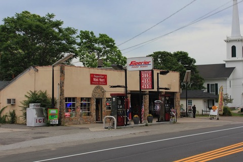
The hamlet of Jamesport with the 1889 Hawkins Store at 1566 Main Road in the foreground and the 1731 Jamesport Meeting House in the distance. (Photo by R. Wines)
In the late 19th and early 20th century, Jamesport and to a lesser degree Aquebogue, developed commercial hamlet centers that served the farm families living along Main Road. In Jamesport three commercial buildings survive from the late 19th century: the 1889 Tuthill House (1572 Main Road), the pre-1873 carriage shop that was converted into the Van Tuyle-Wells Store sometime before 1889 (1601 Main Road ) and the 1889 Hawkins Store (1566 Main Road). In the early 20th century these structures were joined by the c. 1925 Case Hardware Store, the 1938 Griffin Music Store (now Grana Pizza), the 1949 Demidovich barber shop, the double storefront at 1546 Main Road and the circa 1940 Kolenick butcher shop at 430 South Jamesport Avenue. By the 30s and 40s the hamlet center had two grocery stores, a butcher shop, a hardware store, two restaurants, a drug store, a barber shop and even a music store and a Studebaker dealership — all in buildings that survive. Nearby residents called shopping there “going downtown.”
The Aquebogue hamlet did not develop quite so fully. In the 19th century there were a couple of important stores in the area, but these are gone. The only two historic commercial structures that survive are the 1891 Downs general store at 518 Main Road, still a deli, and the 1930 Barowiec Butcher Shop at 548 Main Road, now a bait and tackle shop.
Architectural Significance
The Main Road survey area encompasses a broad range of architectural styles popular in the area from the mid-18th century through the mid-20th century.
18th and Early 19th Century Story-and-a-half Houses
The earliest structures in the area were simple story-and-a-half side gable homes. Today realtors refer to the style as “Cape Cod,” but in reality these were the vernacular North Fork farmhouses built in the 18th and first half of the 19th century in the area. In this survey, we will only use the “Cape” nomenclature for houses built in that shape during the middle decades of the 20th century. Most of these original houses were very small, often less than 500 square feet. Usually, they were “half houses” with a side hall entrance and two front windows, but some, such as the original wing of the Wells-Hutchinson House at 939 Main Road in Aquebogue, were built with a center entrance flanked by single windows on either side that opened directly into the main room of the house, which occupied the entire front two-thirds of the structure. The back third was often divided into two smaller rooms. Exterior ornamentation was minimal, although some of the story-and-a-half houses built in the early 19th century sported Federal or Greek Revival details.
Often these little half-houses are today incorporated into larger newer homes. For instance, the oldest house surviving in the survey area, the circa 1758 Griffing-Wells House at 396 Main Road in Aquebogue, is just the bottom half of the current structure. A Federal doorway and small window openings survive on the lower level from 1758 — as do small windows close to each other on the second level side walls. An incongruous mid-19th century rebuilding converted the house into a two-and-a-half story structure, with no architectural connection between the first and second levels.
Similarly, the original part of the circa 1772 Conklin-Aldrich House at 1612 Main Road (today Junda’s Bakery) is just the first floor of the right half of the house. The rest was added in the mid-19th century or later, as belied by the off center doorway and different window spacing. The Jamesport Parsonage at 1587 Main Road is another example of this practice. The first floor dates to the mid-18th century, but in the 1890s a full second floor and a two-story side wing were added and the house was given a Queen Anne façade. Today, one would never know from exterior appearances that there is a much earlier house inside.
Sometimes these original half-houses appear as side wings of later house — such as the circa 1770 story-and-a-half right wing of the Wells-Hutchinson House in Aquebogue. The only surviving 18th century standalone structure is the Old Corwin House at 612 B Main Road. Ironically that was once incorporated as a side wing of the 1831 gambrel roof house next door, but later separated to serve again as a separate house.
 The Wells-Hutchinson House in Aquebogue with its 1770 original story-and-a-half section on the right and 1850s two-and-a-half story side hall addition on the left.
These story-and-a-half houses continued to be built well into the 19th century. Excellent examples are the 1830 Payne-Aldrich House at 1847 Main Road in Laurel, the 1850 Lewis Terry House at 1967 Main Road in Laurel and the circa 1840 Marcy Cottage at 415 South Jamesport Avenue. Other early 19th century half-houses are today wings of bigger homes. For instance, the 1829 half-house of Gen. David Williamson in Jamesport Hamlet was moved up to Main Road about 1850 and incorporated into the current Williamson House at 1578 Main Road as the back kitchen wing. Similarly, the original 1826 half house of Israel Fanning at 2092 Main Road in Laurel is now the lower part of the left wing of the current house. A two-and-a-half-story Greek Revival block was attached to the original house in the 1830s, then another wing attached to the right of that, and finally the roof was raised on the original 1826 wing in the 1890s.
19th Century Side Hall Houses and the Greek Revival Style
The second vernacular style that became common in the area is the two-and-half story side hall, side gable house. Homes in this configuration began to be built in the early 19th century and became common by the 1830s and 40s as the area recovered form the economic hardships inflicted by the Revolutionary War and began to benefit from improved connections to the growing New York City markets. The side-hall house, except in crowded urban settings, was relatively unique to Long Island and parts of New Jersey. In New England and elsewhere, center hall homes were much more common. However, until the Colonial Revival late in the 19th century, only a couple of center hall homes were built on Main Road — the 1841 main block of the John Woodhull House at 1662 in Jamesport and the 1859 front section of the Squire Halsey Young House at 1117 in Aquebogue. Both reflect their owners’ status as two of the wealthiest residents of the town.
In the first half of the 19th century, roofs were generally relatively steep, roof overhangs were minimal and the siding material was always large shingles, sometimes as much as 36 inches long, applied with 12 inches to the weather and generally painted. The shingles were locally produced, hand split, and probably made of hard pine. In many cases the original shingles have survived to this day. For instance the 1731 Jamesport Meeting House still has its original shingles on the side walls, as does the entire Judge John Woodhull House in Jamesport, along with many others. Indeed, the use of these large wood shingles is one of the defining characteristics of local vernacular architecture not found in nearby New England.
These two-and-a-half-story side-hall houses continued to be built throughout the 19th century. From the 1830s through the 1850s and sometimes beyond, these homes sported restrained Greek Revival ornamentation. Sometimes this was limited to a fine doorway with side lights and a top light or a small frieze beneath the front cornice. To create a more stylish facade, Yankee gutters were sometimes bolted onto the front façade of a house that otherwise had minimal roof overhangs. Often these side hall structures were built as additions to older story-and-a-half structures as the family’s prosperity increased, as happened at the Israel Fanning House in Laurel. Others were built as standalone structures, such as the circa 1835 Woodhull-Warner House at 1636 Main Road. In many of these cases there were also wings added to the backs of these houses to accommodate kitchens and other functional area.
Later in the century, these side hall designs often sported Italianate details, including wide roof overhangs supported by brackets with drop pendants, such as the main block of the Albin-Young-Fanning house in Laurel. Some of the more conservative farmers added almost no ornamentation. Today, many of these side hall structures are attached to still larger additions with front facing gables, as happened with the Fanning-Goodale house at 190 Main Road, the Young-Krupski house at 222 Main Road and the Avery Young House at 958 Main Road, all in Aquebogue.
Surprisingly, there is only one front gable Greek Revival house in the district, the c. 1840 Daniel Tuthill House at the corner of Tuthill’s Lane in Jamesport.
Italianate Influences
By the 1860s, the trend towards “Italian” designs influenced the North Fork as it did the rest of the country. Sometimes these were full blown Italianate mansions, like the 1864 Jedediah Hawkins House at 400 South Jamesport Avenue. The circa 1872 Austin Penny house at 2014 Main Road in Laurel is another example. Both of course, were built by well-to-do sea captains who had “seen the world” and acquired more sophisticated tastes than their stay-at-home farmer neighbors.
The more traditional farm families along Main Road generally built much simpler houses and perhaps added a few Italianate features such as round topped windows, wider bracketed cornices or double front doors. These influences are apparent in many simple homes such as the circa 1865 Luther Moore House at 486 Main Road in the center of Aquebogue hamlet. Sometimes these features were rather clumsily attached to older homes, such as happened at the pre-1858 Albin-Young-Fanning house in Laurel or the circa 1850 James T. Dimon house at 1607 Main Road in Jamesport hamlet. Italianate influences are also apparent in the 1859 front façades of the Jamesport Meeting House and of the 1862 Old Steeple Church in Aquebogue. .
Late 19th Century Styles
Later in the 19th century, there was more diversity in architectural styles, with examples of Carpenter Gothic, Queen Anne and Shingle styles appearing. The best example of Carpenter Gothic is the 1870s John Henry Wells house at 497 Main Road, built by John Elliot Aldrich (see Aldrich’s own house at 621 Main Road). Perhaps the best example of the Queen Anne style is the c. 1890 Jennings-Hubbard House in Aquebogue. The closest approach to a Shingle Style house was the1890 Mees-Sause House at 2050 Main Road in Laurel.
Early 20th Century Cottages and Craftsmen Bungalows
In the 20th century, building styles in the area generally reflected national trends. Early in the century there were a number of end-gable story-and-a-half cottages, such as William Wells’s house at 1197 Main Road in Jamesport. In the teens, 20s and 30s, there are a lot of variants on the bungalow design. Some have significant Craftsman features, such as the circa 1910 example on the corner of Main Road at 299 Shade Tree Lane. Other examples are at 1661, 1327 and 1825 Main Road, which are all slightly more vernacular.
Throughout these decades there are also examples of Colonial Revival design, such as the 1900 Moore-Young House at 756 Main Road in Aquebogue and the 1900 house at 2041 Main Road in Laurel.
Four-squares
And, of course the Four-square, with its many variants, was popular in the area. Most of these were built by first or second generation Polish immigrant farmers. See the 1930 Felix Zaweski house at 1935 Main Road, the Stanley Truskolowski houses at 2109 Main Road, the 1935 example at 2167 Main Road or the nearly identical Four-squares at 1977 and 1985 Main Road that date from 1926 and 1928 respectively. It part, this may have been coincidence, as the Polish immigrants were the expanding population group along Main Road. However, this economical design may also have suited their relatively large families struggling to make it in a new country.
Post War Capes and Ranches
After the second World War, architectural styles came full circle from the little story-and-a-half houses of the 18th century to the small “Cape Cods” that became the preferred style in the late 40s and 50s, although generally in a center hall version. There were also a few center hall Colonial Revivals, such as 1717 Main Road in Jamesport built in 1947.
 The 1952 Albin Zaweski House at 1722 Main Road is typical of the one-story ranch houses that second and third generation Polish farmers built in the 1950s.
By the mid-50s and 60s, the one-story ranch type house became the preferred style of local farmers as they replaced their sprawling older homes with something newer and easier to heat. See, for instance, the 1952 house that Albin Zaweski built at 1722 Main Road, the 1950 house that his brother built at 2010 Main Road and the 1960 house that their cousin Ken Zaweski built at 1891 Main Road. Many other examples of undistinguished generic ranches exist, such as at 894, 921, 1159 and 1456 — all built in the 1950s.
Modernism
Modernism barely touched Main Road. This was always basically a conservative farming community. The only house that comes even close is the flat-roofed house that Vandy Conklin, a farmer’s son, built in 1956 at 1071 Main Road next to his father’s house in Aquebogue.
The Double House
 The Warren Wells house at 260 Main Road in Aquebogue is an excellent example of the double house built to accommodate multigenerational farm families. The right three bays constituted a vernacular side hall house erected about 1860. The four bays on the left, with the cross gable, were added after Warren’s son Herman H. Wells married Jennie R. Wells in 1896.
And finally, one more house style that was once common in the area, but now only survives in a few examples, is the double house. These were generally built to accommodate multigenerational farm families. They were a popular way in the late 19th and early 20th centuries to keep the sons at home and on the farm. When a son was ready to be married, the parents would simply add a large addition onto their own house, with its own front entrance. Sometimes these additions were bigger than the original houses. Then the two generations could live side by side in the same structure, with interconnecting doorways to facilitate communication (or control) between the generations. The two best surviving examples of this phenomenon are the Young-Krupski house at 190 Main Road and the 1860 Warren Wells house at 260 Main Road in Aquebogue, both recently restored by Harold Goodale III.
20th Century Roadside Architecture
As the automobile replaced the horse drawn carriage, Main Road by the 1920s became an increasingly busy thoroughfare. It was the principal access to the rest of the North Fork and was also a popular route for tourists attracted by the area’s many beaches and summer homes.
With the automobile came garages and other facilities to service it. By the late 1940s there were at least ten gas stations along the portion of Main Road in our survey area. Of these all but two survive, although only one, the 1920s Magee Garage at 640 Main Road next to the Modern Snack Bar in Aquebogue still sells gas. One other, the former 1940 Trinowski Texaco Service Station at 1811 Main Road in Jamesport, is still in the automotive service business. It even has one antique pump, not in use, in front.
The 1920s Magee Garage at 640 Main Road, Aquebogue, with Old Steeple Church in the background.
All the other former service stations have been repurposed for other businesses. Fisher’s ESSO Garage at 1399 Main Road on the corner of Washington Avenue in Jamesport is now a hardware store and the 1936 Downs Super Service Station, next to the Downs Store at 1403 on the corner of Edguar Avenue in Aquebogue, is now a design shop. The 1938 Bokina Garage at 272 Main Road in Aquebogue now sells solar energy units. The Laurel Post office has lost the gas pumps it had in the 1920s and now serves just mail. Similarly the 1920s Studebaker Garage at 1549 Main Road in Jamesport has served a whole series of different businesses since selling its last Studebaker in the 1940s or 50s.
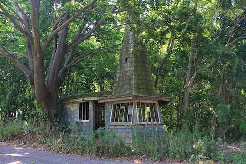 1927 “Witch’s Hat” at 257 Main Road in Aquebogue, which originally sold candy and cigarettes, and also had a gas pump.
Another form of highway architecture that sprang up along Main Road was the road side stand, generally selling farm produce, but often other products too. The best and oldest example is the 1927 “Witch’s Hat” at 257 Main Road in Aquebogue, which originally sold candy and cigarettes, and even had a gas pump too. Amongst the dozen or so farm stands that still line the road are two that date back to the 1930s or 40s: the former Grant Conklin stand in Jamesport and the 1937 Worm-Britenbach stand at 460 Main road in Aquebogue. Both still sell farm products and are maintained in part because zoning codes today would not allow structures like these to be built so close to the road.
The original cement block structure of the 1941 Densieski liquor store at 1527 Main Road in Jamesport is yet another example of roadside architecture. One other example of late 40s roadside architecture should be mentioned, the 1949 Modern Snack Bar at 628 Main Road in Aquebogue. Its neon sign is such a well know landmark that it has even appeared in a television advertisement shown nationwide. The sign was also recognized by the Riverhead Landmarks Commission as a town landmark.
Rusticated Cement Blocks
Ornamental cement block manufacture began in the area starting in the 1920s or possibly slightly before. One plant was within the survey area. Oliver “Olie” Williamson, who lived at 1587 Main Road, was a mason whose family had owned the sandy land just west of Manor Lane for at least a century, figured out how to turn the worthless area at the foot of Sharper’s Hill behind this house into an economic asset by erecting a block manufacturing facility there and mining tje sand to provide his basic raw material. In the 1920s, he appears to have manufactured mainly blocks with a rough finish designed to look like rusticated stone and beveled edges to look like ashlar stone.
Although there were other manufacturers of rusticated blocks in Riverhead and Flanders, Williamson probably used his blocks for many cement block buildings clustered on the Jamesport portion of Main Road. The ashlar blocks (likely his) can be found on the east wall of the 1920s Studebaker Garage (1549 Main Road) and both side walls of the Elbow Room Restaurant (1549 Main Road) next door. An old photo shows that the front of the Elbow Room was also originally ashlar block. The rusticated block shows up on the side walls of the Fisher Garage at 1403 Main Road and also as foundations for many buildings erected in the 1920s. For instance, when the Franklinville Presbyterian Church was moved in 1921 to 1597 Main Road, Jamesport and located directly across the street from Williamson’s house, it is likely that the rusticated blocks used in the foundation were his. Similarly, the rusticated cement blocks used for the modesty panels of the front porch added to the circa 1850 Terry-Brown House at 1492 Main Road were also probably his.
By 1940, Williamson seems to have switched to plane block, which he used to build the Trinowski Texaco Service Station1811 Main Road. He may also have been the builder of the Denesieski Liquor Store the following year with plane block at 1527 Main Road.
Churches and Schools
The survey includes two historic churches, the 1731 Jamesport Meeting House, rebuilt in 1859, and the 1862 Old Steeple Church in Aquebogue. In their current configurations, both represent the very conservative tastes of the local farm populations. They are basically plain white boxes with simple rectangular windows. Except for a few round-top windows in the front and the louvered openings in the belfry that are influenced by the Italianate style, these structures have very little architectural ornamentation. The former 1831 Franklinville church, now an apartment building at 1597 Main Road in Jamesport, was slightly more architecturally interesting with its gothic pointed windows, but was still basically a simple structure.
The survey area also includes a number of school buildings from various eras. The oldest is the 1833 Franklinville Academy at 2070 Main Road in Laurel, converted to a house in the late 19th century. Of the three one-room schoolhouses that once stood along Main Road, only the circa 1870 District #8 school in Aquebogue survives at 866 Main Road, now converted to a house and virtually unrecognizable.
There are also two significant 20th century schools. The 1923 Jamesport School, a large wood frame structure on South Jamesport Avenue, is now much altered and functions as a community center. The 1929 brick Aquebogue School, probably the only architect-designed historic structure in the survey area, is still in use as a school and its front section virtually unaltered since its construction.
Barns and Other Agricultural Structures
Befitting its long agricultural heritage, there are 41 barns in the survey area, and numerous smaller agricultural outbuildings. The earliest barns on the North Fork were always “English” style barns. These were three bays wide, with doors on the middle of the broad side walls, as apposed to “Dutch” style barns with doors on the gable ends. This barn design was brought from East Anglia by the area’s earliest Puritan settlers in the 17th century and variations continued to be built well into the 20th century, even by Polish immigrant families such as the 1928 Felix Zaweski barn at 1935 Main Road in Jamesport that is now Clovis Point Vineyards.
 The early 19th century Reeve Barn at 891 Main Road started as a typical three bay English barn. Over the years two or three more bays were added to the main structure, a carriage house was attached on the left side, s shed were attached to the rear and three decorative gables were to the front. And, finally, the family installed Amish style windows in the early 21st century..
Generally, the older barns were built on an east-west axis with one of the broad sides facing south. This provided shelter on the broad side for livestock and, when the doors were opened, helped warm up the inside. The design was also intended to facilitate thrashing and winnowing in the central “thrashing floor” with both doors open. The main purposes of the barns originally were to store hay and shelter livestock. The best example of an unaltered English barn is the early-19th century Barnabas Corwin Barn at 576 Main Road in Aquebogue, although even that has modern siding.
Over the years these barns were often enlarged, sometimes by adding two or more bays to one end, and often by adding sheds to either the ends or sides, sometimes to all four walls until the original English barn was unrecognizable. One good example of this is the Reeve barn at 891 Main Road in Aquebogue, with its extensions to both sides and sheds to the rear.
As potatoes became an important crop in the mid-19th century, farmers dug storage cellars under their English-style barns. In the early 20th century, they began building separate potato barns, mostly buried in the ground to keep potatoes from freezing in the winter. The best example of this is the small mostly-underground structure from the 1930s built into the bank on the east side of the Daniel Tuthill – Henry P. Tuthill House at 1146 Main Road As the century progressed, these potato barns gradually emerged out of the ground — first as masonry structures with earth banked around them, and later as free standing wood frame and finally metal sided pole barns that were well insulated to keep the potatoes (which generate some warmth on their own) from freezing in the winter.
In the late 20th century and early 21st century, as agriculture became more diversified and more mechanized, the old barns were adapted for new uses, and pole barns were built for equipment storage and other purposes. Some of the old barns have become residences or shops. Others have been converted to wineries. Still others are used for general storage. Many, however, are still in use for agricultural purposes, as the area is part of Suffolk County’s agricultural core. None, however, are still used for potato storage.
Archaeological Sites
The most significant Native American archaeological site along Main Road is “Sieminski Farm Site” at the crest of Sharper’s Hill behind the hamlet of Jamesport. Artifacts from the site have been dated to the transition period between the Archaic Period and the Early Woodland Period (about 3,300 – 2,700 B.P). The site was first excavated in 1940 by Roy Latham, an amateur archaeologists from Orient. The site was professionally re-excavated by William Ritchie (New York State Archaeologist), Irving Rouse (professor, Yale University) and Peter P. Pratt. Along with two similar sites in Orient and one in Shinnecock Hills, it revealed artifacts providing important evidence of the mortuary customs of the little-understood Archaic Period inhabitants.
A letter from Douglas Mackey of the New York State Office of Parks, Recreation and Historic Preservation read into the record of the 2009 environmental impact hearing on the Village at Jamesport project that includes this hill, stated that: ʺWhile the Jamesport Hill site had not been officially determined eligible [to the National Register], that is only because the site was not endangered previously and no request for a formal determination has been made. The site is clearly eligible.ʺ Consequently, we have included this site in our survey area even though it is more than 1,000 feet back from the highway.
Although no other sites along Main Road are as well documented, a quick perusal of a some old scrapbooks reveals numerous accounts of Native American remains being uncovered in the area. Moreover, most of the families that have farmed along Main Road for several generations have extensive collections of Native American artifacts.
Assessment of Significance
The Riverhead Landmarks Preservation Commission has determined that Main Road is an important historic corridor with its surviving farmsteads, houses and commercial buildings that document three centuries of the town’s agricultural history. The Commission has already designated eight individual structures along the corridor as local landmarks and one local historic district in Jamesport Hamlet. Two structures are individually on the National Register: The 1731 Jamesport Meeting House and the 1864 Jedediah Hawkins House. The Commission believes that the entire corridor should be eligible for nomination to the National Register as a historic district.
A more formal assessment can be made using the criteria to establish eligibility for listing on the National Register of Historic Places. Under these guidelines, historic significance is the importance of a property to the history, architecture, archeology, engineering or culture of a community, state, or the nation. The historic significance of a property can be determined in a number of ways:
A. Its association with events or activities that have made a significant contribution to broad patterns of history.
B. Its association with the lives of persons significant in the past.
C. Its embodiment of distinctive characteristics of a type, period or method of construction or that represent the work of a master.
D. Its potential to yield information important in prehistory or history.
In general we believe the resources along Main Road qualify under criteria “A” and “C” for National Register consideration. As a whole, and often individually, the Main Road resources embody significant developments in the agricultural and social history of the area. Moreover, these resources also embody architectural types, some of which are unique to Eastern Long Island and others that are characteristic of their era nationally. At least one resource, and possibly many more, also have the potential to yield information about the area’s Native American prehistory.
We have indicated on our resource list all structures that we believe could be contributing to a potential National Register Historic District. Our preliminary count is that out of a total of 287 structures and other resources along the Main Road corridor, 240 or 83.6% of the total may be potentially contributory to a National Register District.
Period of Significance: 1731-1963
The Main Road corridor is historically significant, under criteria “A,” because of the more than three centuries of the area’s evolving agricultural history it represents. Although for most of our period of significance, Main Road was primarily a farming community, it also was home to various merchants and trades people who served that community such as blacksmiths and carpenters. There are also a surprising number of homes of carpenters. In addition, many of the houses and farm buildings tell the important story of the Polish immigrant community that came to this area in the early 20th century and transformed it in subsequent decades. Finally, the corridor also includes numerous service stations, farm stands and other examples of road-side architecture that document Main Road’s role in the emergence of the automobile as a means of transport.
The suggested period of significance starts with 1731 when the area’s pioneers built the Jamesport Meeting House, the oldest structure along the corridor. The period of significance runs through the early 1960s since even the modest generic Capes and Ranches of the postwar period were still directly connected to the area’s rich agricultural heritage and were generally built by descendants of either the Puritan pioneers of the 1700s or the Polish immigrants who came to dominate the area in the early 20th century.
As the chart above helps illustrate, there was remarkable continuity in building activity on Main Road from the 1700s through the early 1960s. The survey area witnessed gradually increasing construction of both homes and agricultural buildings as farm families built new homes for themselves and their children, and as other tradesmen and merchants built homes and shops to serve the core farm community along Main Road. This continued right through the 1950s and into the early 60s, with many of the new ranch homes being constructed for farmers who were also still busy putting up new potato barns.
After the early 60s things changed rapidly on Main Road. As potato production declined, farm families stopped building new homes and barns along Main Road. And, as traffic increased sharply, very few non-farmers chose to build homes along Main Road, preferring instead the quieter subdivisions that sprang up well removed from the artery. Overall the rate construction has drooped off sharply since the early 1960s and the nature of new building has changed considerably. The few new structures are mostly commercial, and hardly any homes have been built directly on Main Road in the last few decades. Thus, the early 1960s provide a natural end to the period of significance.
Although most of the homes built in the post war decades are undistinguished Capes and Ranches that would not normally qualify on their own for a National Register district, we think it important to include these homes as contributing resources because they were often built by the sons and daughters of established farm families and are part of the same historical continuum.
Survey Methodology
The starting point for this survey was a series of surveys conducted in 1977 by the Society for the Preservation of Long Island Antiquities (SPLIA) under the sponsorship of the Riverhead Town Landmarks and Preservation Society, a predecessor of the Riverhead Landmarks Preservation Commission. We transcribed information from these 1977 survey forms into our electronic database. We also added the USN numbers of each structure from the State Historic Preservation Office’s database. The Landmarks Preservation Commission obtained a copy of the Riverhead portion of this database approximately 10 years ago and put considerable energy into updating addresses and correcting information to create the “Riverhead Survey of Historic Resources,” which currently contains about 750 historic resources.
We have photographed all the buildings along Main Road from Route 105 eastward to the Southold town line. We obtained tax map numbers from the town of Riverhead’s integrated data system. We obtained construction dates (generally only accurate for the 20th century) from the town Assessors Office. We consulted historic maps dating form 1858, 1873 and 1909 to obtain names of owners of homes standing on those dates. We used state and federal census information and numerous primary and secondary sources for additional information. Finally, we conducted numerous interviews with individuals who currently or once lived on Main Road to garner there recollections and family stories. We also held a public information meeting to gather additional stories. All of this information has been integrated into a database table using Google docs.
This has been an all volunteer project (see Acknowledgements) by members of the Commission and interested community members. Although for survey purposes, descriptions are only necessary of buildings considered historic, we have included descriptions of all of the structures on the Main Road corridor in anticipation of needing to provide that information for a National Register nomination.
Boundaries
Our original intention was to survey all of the resources along the nearly five miles of Main Road from its intersection with Route 105 east through the hamlets of Aquebogue, Jamesport and part of Laurel to the Southold town line. While Main Road extends about half a mile further west, most of the historic resources that once existed in this area have been replaced by recent commercial development, so Route 105 makes a natural western boundary, as does the town line in the east. As we worked, we discovered that short contiguous sections of several intersecting roads contained resources that were part of the same historic story, so we have added those to our survey.
Significant stretches of Main Road are included in “Rural Corridor” and “Hamlet Center” zones designed to encourage preservation of existing historic structures and to require new construction compatible in look and scale. These zones generally stretch 500 feet back from Main Road. We have generally followed these boundaries defining our survey area. Where there is no special zoning along the roadway, we have included all properties that abut Main Road on either the north or south sides, but if the properties are more than 500 feet deep, we have only included the frontage unless there is a significant historic resource further back. Our boundaries are also drawn so as to include the entire locally designated historic district in Jamesport Hamlet.
Within the survey area, we have found that there is a very high concentration of historic resources that could be found contributing to a National Register Historic District — 240 or 83.6% of the total of 287 total structures and other resources. Beyond the bounds of the district, the picture is very different. Except for small sections included in the survey area, these intersecting streets are mostly lined with either recent homes or open fields. Between the cross streets, there are generally open fields to both the north and south beyond the Main Road corridor structures, although in some parts of Aquebogue and Jamesport former fields have been replaced by residential developments, usually set well back from Main Road.
The Landmarks Commission believes that both South Jamesport and the Jamesport Camp Meeting Grounds would also qualify for National Register Historic District designations. Similarly the Commission believes that the Sound Avenue Corridor is a candidate for National Register designation. However, both of these potential districts are well separated from the Main Road corridor.
Threats to Main Road Resources
As commercial development encroaches further and further east from western Suffolk County, pressures to develop vacant properties along Main Road grow more intense. Property taxes increase each year and property owners are forced to either raze structures that are no longer viable, or come up with other solutions for buildings that are seen as nonfunctional or unsuitable for residential or commercial use. These pressures are becoming ever more intense.
Main Road’s first five miles on the North Fork set the pattern for the entire way east through Mattituck, Cutchogue, Southold, Greenport and Orient. Our Master Plan in Riverhead calls for hamlet and rural corridor zoning uses that are consistently being challenged by landowners who see no value in historic preservation. The agricultural heritage and architectural character that is endemic to this part of Long Island’s East End will undoubtedly disappear in a generation without the implementation of new districts that protect these valuable resources. It is with these concerns in mind that we propose a National Register Historic District along the Main Road corridor in Aquebogue, Jamesport and Laurel with the hopes that recognition of our resources and incentives will encourage renovation, restoration and reuse.
While most of the resources along Main Road are well maintained, there are at least thirteen houses and a number of barns and outbuildings that are abandoned and seriously threatened. These include:
Witch’s Hat at 257 Main Road, the most unusual example of roadside architecture on Main Road
Griffing-Wells house at 296 Main Road, one of the oldest houses in the survey.
The Alva Corwin House, 534 Main Road, a wonderful example of the small gambrel roof house common in the area in the early 19th century, but rare today.
The John Elliot Aldrich house at 621 Main Road, one of the most architecturally ambitious houses in the survey area.
The Squire Halsey Young house at 1117 Main Road, one of the most historically significant houses on Main Road with connections with the town’s founders and slave holding.
The other threatened resources are less significant architecturally and historically and surprisingly include several mid-20th century homes which are apparently more valuable because of their development potential than as residences.
It is our hope that a National Register Historic District would both provide access to tax credits that would directly help property owners preserve these many historic resources and would also provide recognition of the historic importance of the area.
Lost Resources
The 1977 SPLIA surveys included 102 resources that lie within the boundaries of the current Main Road Survey District. Of these structures, 2 (2.0%) have been moved to other locations in the town and 17 (16.7%) have been either demolished or altered beyond recognition. The total loss rate over the past 35 years has been 18.7%.
These are resources that appeared in 1977 historic resource surveys conducted by SPLIA.
10306.000482
ALDRICH-KERSNOWSKI HOUSE
Aquebogue
Demolished
10306.000465
DIAMON-HOPPE HOUSE
Aquebogue
Demolished
10306.000493
EBENEZER YOUNG HOUSE
Aquebogue
Demolished
10306.000494
GRIFFIN-CORWIN HOUSE
Aquebogue
Demolished
10306.000483
YOUNG/LEAVITTS HOUSE
Aquebogue
Demolished
10306.000473
CORWIN-TOWNSEND HOUSE
Aquebogue
Demolished
10306.000485
GEORGE REEVE HOUSE
Aquebogue
Moved
10306.000551
REEVE-BROWN HOUSE
Jamesport
Drastically altered
10306.000554
YETTER-MOORE-COBEY HOUSE
Jamesport
Demolished
10306.000549
C. S. TUTHILL HOUSE & OFFICE (STROHSON)
Jamesport
Demolished
10306.000552
REEVE-HAWKINS HOUSE (BLACK ELK ANTIQUES)
Jamesport
Demolished
10306.000557
SEAMAN HOUSE (KARP REALTY)
Jamesport
Demolished
10306.000561
TARABOCCHIA HOUSE
Jamesport
Demolished
10306.000642
PETTY-MCGOY-CANTLON HOUSE
Jamesport
Demolished
10306.000654
DONOVAN / PHILLIPS HOUSE
Laurel
Demolished
10306.000643
SKIDMORE / OLISH HOUSE
Laurel
Demolished
10306.000655
WILBUR-FANNING HOUSE
Laurel
Moved
Acknowledgements
A long list of people have assisted in our research, either by providing photos and documents or by sharing their recollections of their family’s and neighborhood’s history. Amongst these were: John Anderson, Skelly Britenbach, Gerard Boutcher, Lisa Dabrowski, Nancy Dillingham, Joe Ditusa, Willard Downs, Donald Fisher, Rose Marie Hubbard, John Kratoville, Tom Kolowasick, Florence Kolowasick, Charles Massoud, ,Bernice Santangelo, Theresa Sieminski Shaffery, Susan Wells, Ken Zaweski. Town historian Georgette Case and Ned Smith, the librarian at the Suffolk County Historical Society, have both assisted in our research.
The Riverhead Town Board, Sean Walter, Supervisor, has enthusiastically supported this historic resource survey and the prospect of a National Register Historic District designation for Main Road. We especially want to thank council person Jodi Giglio, the board’s liaison to the Landmarks Preservation Commission, who has encouraged this project in many ways.
We also want to thank Lorraine E. Weiss, Historic Preservation Planner and Daniel McEneny, Long Island Field Representative, New York Office of Parks, Recreation and Historic Preservation, for their assistance, advice and encouragement at every step in the process.
And finally, Cliff Baldwin has done all of the photography and a huge amount of the basic work of assembling and combining data from the 1977 SPLIA Survey, the town’s Assessors Records and numerous sources of earlier research. Two members of the Landmarks Preservation Commission, Georgette Keller and Peter Lucas have also helped in various ways on this survey. And, former Landmarks Commission Member (and wife of the current chair) Nancy Gilbert helped with interpretation of the evidence and with proof reading.
Bibliography
Austen, Barbara, ed. Journey Through Time: The Riverhead Bicentennial, 1792-1992. Riverhead Bicentennial Commission, 1992.
Beers, F. W. Atlas of Long Island. 1873.
Beers, F. W. Atlas of Long Island, N.Y. Beers, Comstock & Cline, 1873.
Case, Georgette Lane. We Will Not Forget: Riverhead’s Civil War Soldiers & Sailors. 2011.
Case, Georgette Lane. Riverhead Town Supervisors, 1792-2010. 2010
Chace, J., Jr. Map of Suffolk County, from Surveys by J. Chace, Jr.. Philadelphia: John Douglass, publisher, 1858.
Downs, Arthur Channing, Jr, ed. Riverhead Town Records, 1792-1886. The Long Islander, 1967.
Downs, Mary. Scrapbooks, MSS. Private Collection.
Hyde, F. Belcher. Atlas of Suffolk County, Vol. II. 1909.
Hallock, Lucius H. Hallock Genealogy. 1926.
Mather, Frederic Gregory. The Refugees of 1776 from Long Island to Connecticut, 1913, reprinted by Genealogical Publishing Co., Inc., Baltimore, 1972.
Riverhead Bicentennial Album. Town of Riverhead, 1976.
Riverhead, Town of. Assessors Records. Electronic and paper records of the Assessors Office.
Society for the Preservation of Long Island Antiquities ()SPLI). Survey of Riverhead Historic Resources, MSS. Collections of Suffolk County Historical Society and Riverhead Town Historian, circa 1977.
Stark, Thomas M. Riverhead: The Halcyon Years 1861-1919. Maple Hill Press, 2005.
Suffolk County’s Ten Great Townships. c 1937.
Young, Ida. MSS scrapbook. Collection of Suffolk County Historical Society.
Wines, Richard. Unpublished research: Jamesport Slide Show; Historic Jamesport House Tours; Aquebogue/Jamesport/Northville Tour
Wines, Virginia. Albums I – XXXIII, MSS; Hallockville Museum Farm
Wines, Virginia. Pioneers of Riverhead Town, Suffolk County Historical Society, 1981.
Wines, Virginia. “West from the Canoe Place: A Study of the First and Second Aquebogue Divisions,” Suffolk County Historical Society, 1975.
US Census (1790-1940)
NY State Census (1915, 1925)
Note on Historic Maps
The two most useful sources for identifying owners of houses on Main Road are F. W. Beers, Atlas of Long Island, 1873 and F. Belcher Hyde, Atlas of Suffolk County, 1909. These are often simply referred to in the text as the “1909 map” or the “1873 map.” There is also a map done in 1858 by J. Chace, but it is more difficult to determine locations precisely. All of these maps contain numerous errors and omissions.
Note on the 1977 SPLIA Survey
A pioneering survey was done by the Society for the Preservation of Long Island Antiquities (SPLIA) under the auspices of the Riverhead Preservation League in 1977. We have incorporated much of the information from the survey, with corrections where necessary, and added more information whenever possible. Unfortunately, that survey did not include street addresses or tax map numbers. Also, the then-current home owner was often used as a resource name. Consequently, we have often changed the resource name to reflect first owners, or families that owned the resource for many years. We have also attempted to add historical and social information about the owners, which was almost totally absent from the 1977 survey.
The survival of local journalism depends on your support.
We are a small family-owned operation. You rely on us to stay informed, and we depend on you to make our work possible. Just a few dollars can help us continue to bring this important service to our community.
Support RiverheadLOCAL today.